At least 38 people were killed when a magnitude-7.7 earthquake struck off the eastern coast of Indonesia before dawn on Saturday (Aug. 15), as rescue teams struggled to reach the region closest to the epicentre with roads blocked by landslides and communications networks down.
Indonesia's geophysics agency, BMKG, recorded the quake at 4:58 a.m. local time at a depth of 15 kilometres off Flores Island in East Nusa Tenggara Province. Strong shaking was felt across three provinces — East Nusa Tenggara, West Nusa Tenggara and parts of South Sulawesi — with residents in several areas reporting tremors that lasted about one minute, Reuters reported. Several aftershocks followed, including one of magnitude 6.1.
The death toll could climb further. Teams had yet to reach Nagekeo, the regency closest to the epicentre, where communications signals were disrupted and road access was cut off by landslides. A second team was attempting to reach the area by ferry.
"As of 15:00, the recorded figures are 38 fatalities, two people seriously injured, 11 with minor injuries," said Suharyanto, head of the National Disaster Management Agency, known by its Indonesian acronym BNPB, at a televised press conference. He added that approximately 2,000 people had evacuated to safer ground.
In Maumere, the main town in Sikka Regency on Flores Island, rescue agency chief Fathur Rahman said teams had recovered 20 bodies, found six injured survivors and were working to free two people still trapped under rubble. Fathur told Reuters that Nagekeo remained unreachable and that communications there had been severely affected.
Emanuel Melkiades Laka Lena, governor of East Nusa Tenggara Province, said at least five of the victims died when structures collapsed on them as they slept. The BNPB said residents across the affected provinces "felt the shock and scattered out of their homes."
"The quake was massive, the shock was so strong — we were resting at home with family," Nona, a 51-year-old resident of Talibura village in East Nusa Tenggara, told Reuters. "There were 13 of us inside the house and we all ran to save ourselves."
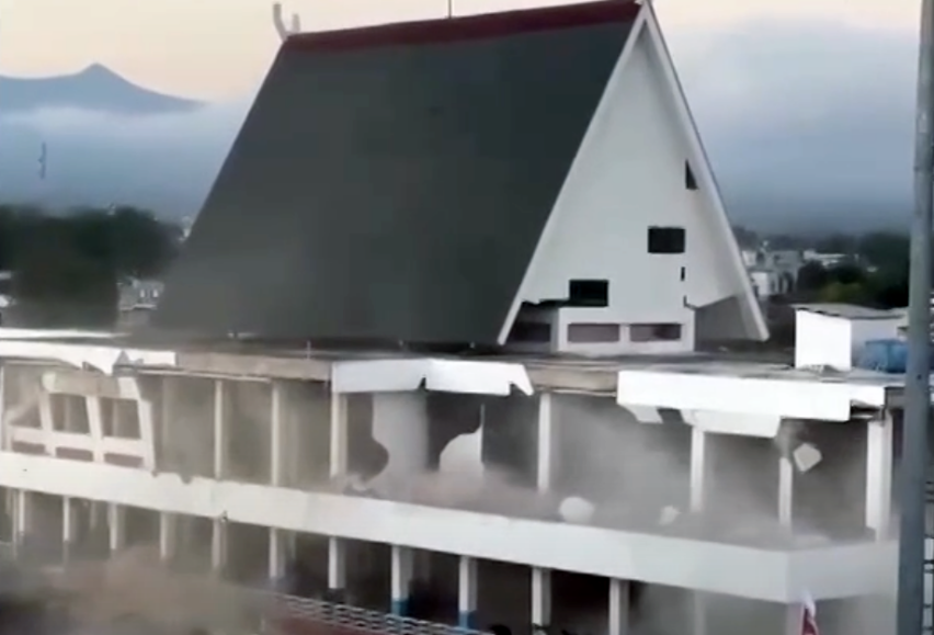
Video verified by Reuters showed part of a building at a port in Maumere collapsing into dust and rubble as people in the street screamed and fled. A hospital in the Ende district was also evacuating patients outdoors, footage from Kompas TV showed, and at least one landslide was reported in the province.
In Nagekeo, about 2,000 residents evacuated, the BNPB said. The agency also reported damage to houses, warehouses and government facilities across the regency, along with power outages and traffic congestion.
BMKG issued a tsunami warning after the quake, then lifted it roughly three hours later. Waves of less than one metre were recorded at several coastal locations. Australia's tsunami warning centre said the earthquake posed no threat to the Australian mainland, its islands or territories.
A magnitude-7.5 earthquake struck the same area in 1992, causing extensive destruction. Indonesia straddles the Pacific Ring of Fire, a seismically active belt where tectonic plates converge, producing frequent earthquakes and volcanic eruptions.
The Indonesia disaster came five days after a magnitude-7.4 earthquake struck Colombia on Aug. 10, shaking Cali, Manizales, Medellín and the coffee-growing Eje Cafetero region and forcing evacuations across several departments.